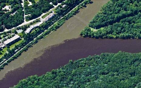
The Minnesota River starts on the western border of Minnesota, and flows first southeast and then northeast to meet up with the Mississippi at Fort Snelling, just below the Minneapolis-St. Paul Airport. In the Minnesota, river bank erosion accounts for more than half of the sediment in the river. This sediment moves down the river, changing habitats. Flows in the river have increased as well, nearly doubling in the past twenty years. Tile drainage of farm lands has virtually eliminated storage of the water on the land. This means that when rains come, and when snows melt, water rushes down the river, scouring the banks and causing yet more erosion. The result is a muddy mix of silt and water that visibly pollutes the Mississippi at it's confluence, as shown in the above photo from Minnesota Public Radio. More rain and more forceful storms exacerbate the problem. (photo by MPCA)
The Minnesota is a river in tough shape. The cost of repairing this damage is high, and will require significant change in farming practices to bring it back to health. John wrapped up his talk by talking about the positive impacts that groups like LWV can have by working to prevent, plan and prepare. Read more about the problems on the Minnesota River in this October 2017 report by the Minnesota Pollution Control Agency. Many thanks to John for taking time on a beautiful Saturday to be a guest speaker at our Annual Meeting!
0 Comments
Leave a Reply. |
| LWV Upper Mississippi River Region | UMRR blog |
 RSS Feed