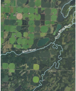
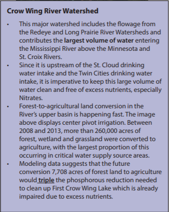
 On Thursday, March 8, League of Women Voters of Brainerd (Minnesota) hosted Anna Bosch of the Minnesota Pollution Control Agency in a discussion of water quality on the Upper Mississippi. (The Mississippi River headwaters are in northern Minnesota and the river travels nearly a third of its length inside Minnesota. When Minnesotans talk about the “Upper Mississippi”, they mean the stretch of the river that flows from the Headwaters to just north of the Twin Cities.) Anna talked about work the MPCA is doing to identify water quality problems and threats in the Upper Mississippi, and to work with local governments to protect and improve water quality. Click here for the document that Anna used as the basis for her talk. The first 350 miles of the river flow through forests and wetlands. Only 4% of the land is developed in this part of the basin, and 13% is in crop and pasture. Water quality in this area is very good, and the focus of the efforts here are on protecting water quality. Not only is there significant protection to the river offered by the surrounding forests but the river is spring-fed; these groundwater contributions sustain both flow and water quality in the river. 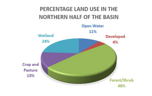 In a previous blog post, we discussed problems with groundwater depletion, stream warming and stream flow loss as well as increasing levels of nitrate in both surface and groundwater. When Anna spoke, she pointed out similar issues in the Crow Wing River Watershed. Here, lands that had been in tree plantations are being cleared and replaced by crops, primarily irrigated potatoes. This conversion removes protection for the river. Cultivating the land can increase sedimentation; fertilizers used on the crops can increase nitrate in surface and groundwater, and irrigation lowers groundwater levels which impacts the flow of groundwater into the river. This combination of changes has significant impacts on the river, and those downstream who rely on it for drinking water. According to MPCA, “for every 10% decrease in forest cover … the cost of water treatment for downstream communities increases by 20%.” The Upper Upper Mississippi is a river with excellent water quality in the river and most of the lakes in its watershed. It flows through the land of cabins and resorts; recreational fishing and water recreation in winter and summer is a major industry. Land uses here are changing which will result in changes in this river. Numerous challenges face Minnesotans as they balance growth and development with recreational uses and drinking water needs.
0 Comments
Leave a Reply. |
| LWV Upper Mississippi River Region | UMRR blog |
 RSS Feed